
A soulfully satisfying and equally rewarding hike on the island of Lombok, Indonesia turns easily into a 3 days 2 nights trek, should you opt to hike down to the crater lake and take a dip in the neighboring all natural hot springs. For simplicity, I will go straight to the details.

Day 1: Start hiking from Senaru, ~600 meters (1975 ft) all the way to the camp area at rim, 2599 meters (8527 ft) leading to an elevation gain of around 6550 ft in approximately 7.5 kms (4.6 miles) and 7 hours. The climb is paved soil for the most part and rocky for the last 1500 ft.

Day 2: Hike down from the camp site to the crater lake at 1982 meters (6500 ft) in little over an hour and hike up to Sembalun side camp site at 2615 meters (8580 ft) in 2.5 hours resulting in a cumulative elevation change of 4100 ft. The hike down is rocky and steep as you lose 2027 ft in little over 2 kms (1.2 miles). The climb up on the contrary is steady for the first 2 kms through the savanna but gains elevation quickly for the remaining 1600 ft in a very rocky kilometer or so. This patch of trail is paved with cemented steps leading all the way to the top of the rim on Sembalun side.

Day 3: Climb up from 2615 meters (8580 ft) to 3726 meters (12224 ft) in 2.5+ kms and 3.5 hours. That’s a climb of around 3645 ft through loose ash, gravel, and rocks. Once up to 2900 meters (9515 ft), you get a steady break for half a kilometer before the grade goes steep to 40 degrees on what can basically be compared to hiking on sand. Picture at least 1.5 kilometers on this unstable terrain. Heading back to the camp site may take an hour and add another 4 hours to hike down from camp site to base in Sembalun, 1150 meters (3772 ft).
In short, Total Elevation Gain to the Summit (Up, up & up) – 10195 ft (Senaru)
Total Elevation Change to the Summit (Incl Crater Lake) – 12222 ft (Senaru)
Total Elevation Drop from the Summit – 8452 ft (Sembalun)

Rewards galore when on top… first the daybreak (above), then the sunrise (below).
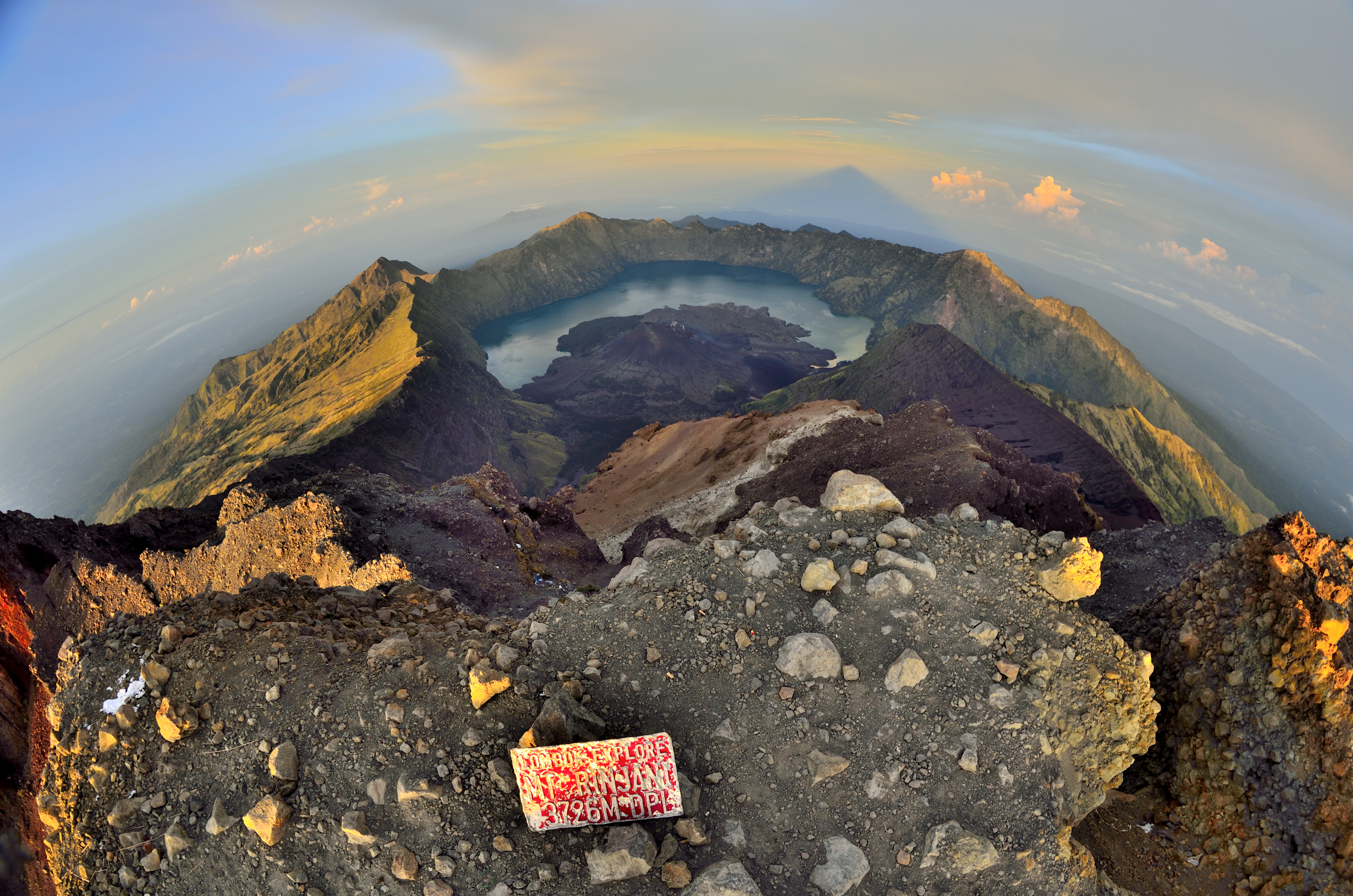
There is another volcanic crater, although lakeless (not in picture) on the side opposite to the crater lake. Reminds of Gunung Agung.

Luar biasa pemandangan yang terdapat di pegunungan rinjani